call Us now for
your Next Trip
+977 1 4423334

Round Annapurna Trek - 18 Days

Round Annapurna TrekRound Annapurna TrekRound Annapurna Trek
Round Annapurna Trek
View of mt. Annapurna III on the way to Manang
View of Humde Airport and Mounains
Trip-costfrom us$ 1250 ( Per Person )
  • Duration: 18 Days
  • Destination: Nepal
  • Trip Grade: Moderate
  • Trip Style: Trekking
  • Accomodation: Hotel + Lodges
  • Transportation: Tourist Bus / Jeep
  • Meals: Breakfast + Lunch + Dinner
  • Min. Age: 2
More Facts Less Facts

Round Annapurna Trek  is Nepal’s most popular long trek. It follows almost 80 km Annapurna Range in central Nepal. It begins at a comfortable altitude of 1100m, rising daily maximum 1000m.  to each overnight stop, ensuring steady acclimatization. The scenery gradually changes from lush forests and terraced farmlands to more open country as the high peaks begin to appear and the effects of the rain shadow area. Lowland Hindu communities gradually give way to Buddhist communities of Tibetan origin. Residents of the numerous villages of Gurung, Magar, Thakali, Chhetri and Brahmins on the route will welcome you.

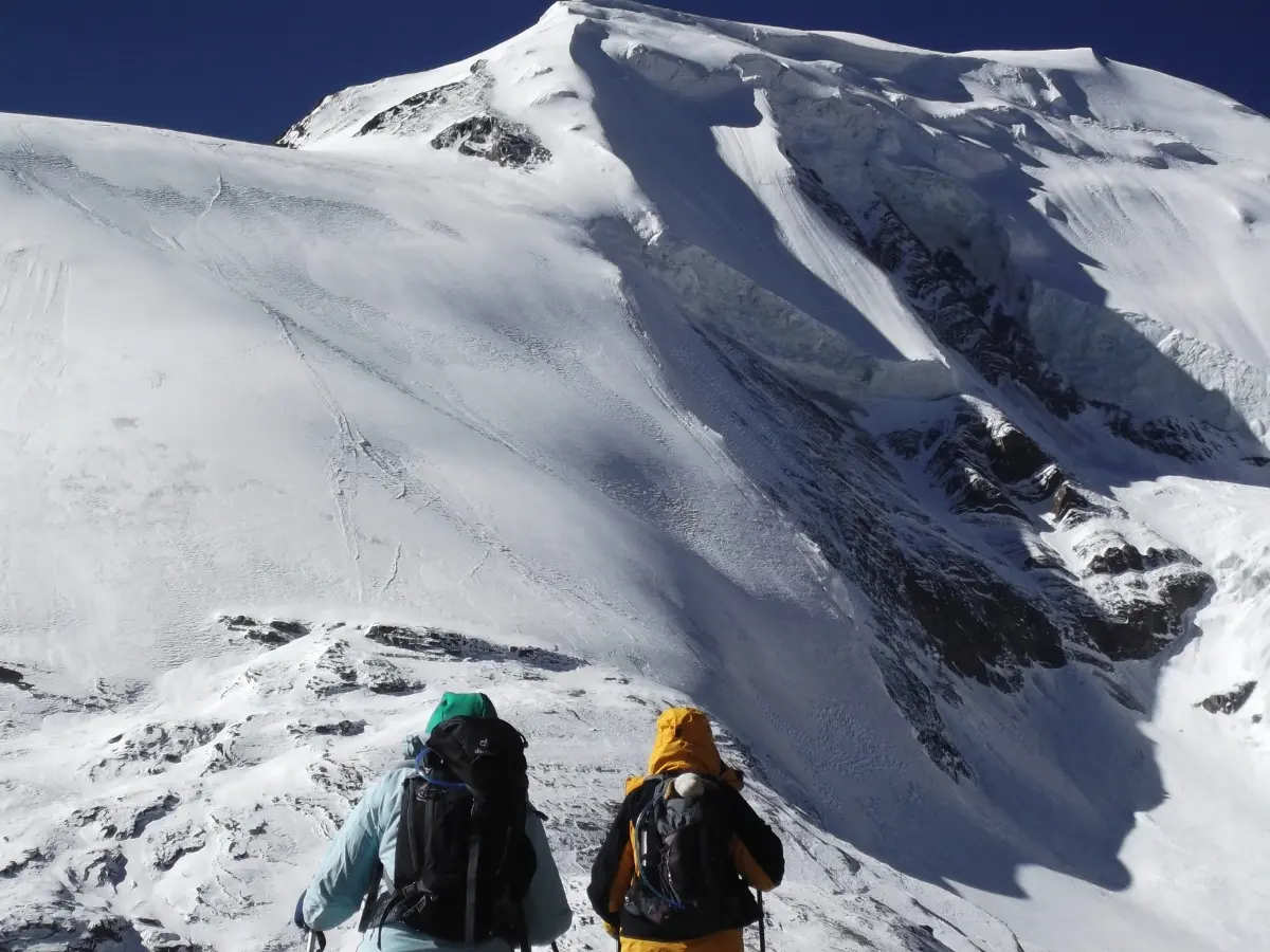
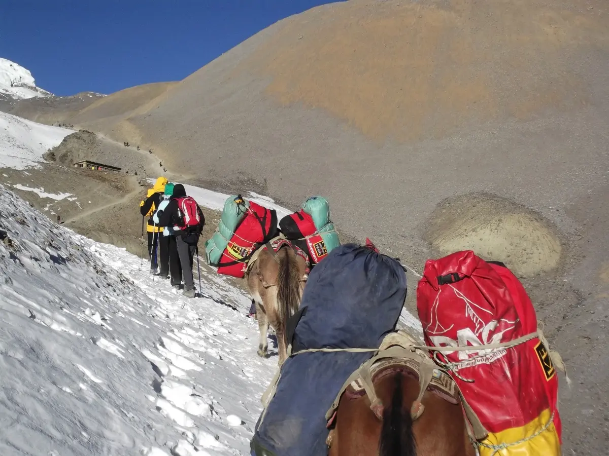
Highlights of the Annapurna Circuit Trek include the high trail from Upper Pisang through Ghyaru and Ngawal to Braga (with its ancient Gompa) with magnificent views of Annapurna II and IV. Manang (3540m) is the largest village and offers perfect views of Gangapurna and Annapurna III. The high pass over the Thorung La (5416m : 17765ft.) is an adventurous day in the whole trek. Its summit offers superb views in all directions, before descending 1700m to Muktinath. Kagbeni is an ancient stone village and holiest Beni (meeting point of two rivers) on the Kali Gandaki River and is also the gateway to Upper  Mustang. 

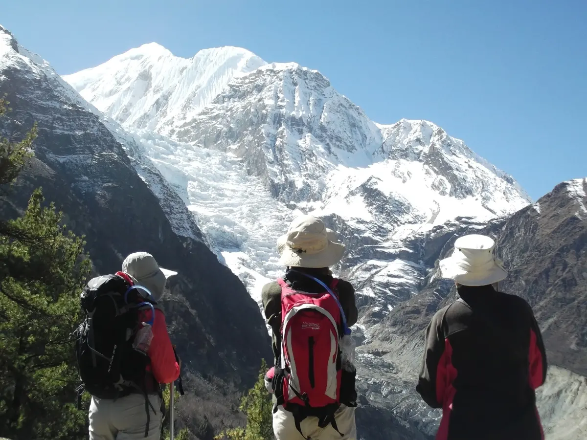
Jomsom has an airport with flights to Pokhara for those with limited time. A bus from Jomsom to Tatopani has recently operated. From Tatopani (hot springs) the trail leaves the road and leads you through magnificent forests rhododendron to Ghorepani and a sunrise trek to Poon Hill to view the panoramic scenery of Mt. Dhaulagiri, Mt. Annapurna, Mt. Manaslu, Mt. Nilgiri, Mt. Fishtail (also known as Machhapuchhare), Mt. Hiunchuli, Mt. Lamjung Himal  the Himalayan peaks. From there the trail descends through farmlands and forests towards to Tikhedhunga and trek ends at Pokhara with its beautiful Phewa Lake, and your hotel.

Spring (March – May) and autumn (September – November) are the most popular months. Good boots, warm clothing (including a down jacket) and a sleeping bag are recommended, plus a day pack with water bottles, a hat and sunscreen, cameras and a torch.

Trip Highlights

  • Best view of panoramic Mountain Peaks
  • Spectacular Himalayan Sunrise View
  • Rain shadow area
  • Adventurous Journey
  • Life time experience
  • Cultural and Natural Trek
  • Close view of Mt. Annapurna I, Mt. Dhaulagiri and other surrounding peaks
  • Home of legendary Gurung  and Magar people ( re-known as a warrior )
  • Mixed culture and custom
  • Rhododendron forest and with native flora and fauna
  • Maximum elevation to reach 5416m./ 17765ft Throng La pass

Day to day outline itinerary

Day 01: Arrive Kathmandu (1 300m/4 264ft): Walkers Expedition staff will meet and transfer you to your hotel.

Day 02: Kathmandu City Sightseeing tour and Preparation for trek

Day 03: Kathmandu - Chyamje (1200m): 10-11 hrs drive

Day 04: Chyamje- Dharapani (1960m/6430ft): 5-6 hrs

Day 05: Dharapani - Chame (2710m/8 891ft): 5-6 hrs

Day 06: Chame - Pisang (3 300m/10 824ft): 5-6 hrs

Day 07: Pisang – Ngawal (3660m/12008ft): 4-5 hrs

Day 08: Ngawal – Manang (3540m/11615ft): 3-4 hrs.

Day 09: Manang: Acclimatization and exploration day

Day 10: Manang - Yak Kharka (4110m/13484ft): 3-4 hrs

Day 11: Yak Kharka - Thorung Phedi – High Camp (4600m/15 092ft): 3-4 hrs Phedi and another 2 Hours to High Camp

Day 12: Thorung Phedi or High Camp - Muktinath (3800/12467ft): 8-10 hrs

Day 13: Muktinath - Tatopani (1200m/3937ft): 6-8 hrs drive

Day 14: Tatopani - Ghorepani (2850m/9350ft): 7-8 hrs

Day 15: Ghorepani - Poon hill (3210m/10528ft) – Tikhedhunga 6-7 hrs

Day 16: Tikhedhuga - Pokhara (910m/2986ft), 3-4 hrs walk, 45 min drive.

Day 17: Pokhara - Kathmandu (1300m /4264ft), 6 hrs drive

Day 18: Final departure

Cost Details

Cost Includes
  • Airport transfers 
  • Hotel accommodations in Kathmandu
  • Hotel accommodations in Pokhara
  • City tour by private transport 
  • Tourist Bus Transportation Pokhara – Kathamndu
  • Public Bus transportation Kathmandu- Beshi sahar- Chayamje
  • Public Bus transportation Muktinath – Tatopani
  • Annapurna Conservation permit
  • TIMS Permits
  • Trekking equipment such as down filled sleeping bag and duffel bag.
  • An English-speaking Govt. registered trekking guide and local porters to carry luggage (2 trekkers : 1 porter)
  • Guide and porter salaries, insurance, equipment, transport, food and lodging
  • Private transport Nayapul  to Pokhara 
  • 3 Meals (Breakfast, Lunch and Dinner) along the way to trek 
  • Hot drinks (Tea and Coffee) during the meal time.
  • Purified/Iodine  Drinking water
  • All lodge accommodations on twin sharing basis ( private room share toilet) 
  • A comprehensive first aid medical kit
Cost Excludes
  • City entrance fees in Kathmandu and Pokhara
  • Tour guide 
  • Food in Kathmandu and Pokhara
  • Boiled  / bottled water
  • Net / Wi-Fi charges
  • Drinks
  • Personal expenses
  • Travel insurance and evacuation charges
  • Tips

Detail Itinerary

Day 01Arrive Kathmandu (1 300m/4 264ft): Walkers Expedition staff will meet and transfer you to your hotel.Walkers Expedition Airport Representative will meet you outside the Terminal Hall. Please, look for our Walkers Expeditions play card. Transfer to hotel. Afternoon stroll Tourist colorful market Thamel down town.
Overnight in Kathmandu Hotel with breakfast

Day 02Kathmandu City Sightseeing tour and Preparation for trekAfter breakfast, proceed for sightseeing tours to world heritage sites of Pashupatinath Temple (the Hindu Temple) on the bank of sacred Bagmati River, Bodhanath Stupa the biggest Buddhist Stupa architecture in the world! Swoyambhunath Stupa (~the 2500 years old legendary Stupa on the hillock) also nick-named as monkey temple. Your day tour ends Kathmandu Durbar Square Showcasing living goddess Kumari Temple, the Kaal Bhairav, the Swet Bhairav, the freak Street and more.
Overnight in Kathmandu at Hotel with breakfast

Day 03Kathmandu - Chyamje (1200m): 10-11 hrs driveAfter an early breakfast, bus drive to 170km westwards to the trekking point Beshi Sahar. The road follows and crosses rivers including the Trisuli, Marsyangdi and Ngadi. The Valley onwards to Besi Sahar before continuing up a minor road to Syange (with a high waterfall) and on to Jagat ~ Chamje. We will follow the Marsyangdi River for six days, to near its source on the North Annapurna Glacier.
Overnight in Chyamje at Lodge
Meal: Breakfast, Lunch & Dinner

Day 04Chyamje- Dharapani (1960m/6430ft): 5-6 hrsAfter breakfast the trail descends, then climbs through rocky forest to the Chamje. Cross the suspension bridge over the Marsyangdi, then climb steadily to the Tal Village (1700m). The trail continues barley, wheat and potato fields and through pine forests to Dharapani.
Overnight in Dharapani at Lodge
Meal: Breakfast, Lunch & Dinner

Day 05Dharapani - Chame (2710m/8 891ft): 5-6 hrsToday the valley swings westwards: we negotiate steep forested ridges and cross several landslides as we ascend the southern side of the valley. Sensational views of the Manaslu Himal, Lamjung Himal, and Annapurna will gradually rise to our left; and come into full view as we approach the large mani wall before Chame. This is the district headquarters of the Manang Valley.
Overnight in Chame at Lodge
Meal: Breakfast, Lunch & Dinner

Day 06Chame - Pisang (3 300m/10 824ft): 5-6 hrsA steep and narrow path, through a dense fir and pine forest, leads to a gigantic curved, ice-carved rock face above Bhratang: which rises 1500m above the river, the path re-crosses the river and ascends, opposite the wall, into the classic U-shaped upper Manang Valley. The views become more exciting .
Overnight in Lower Pisang at Lodge
Meal: Breakfast, Lunch & Dinner

Day 07Pisang – Ngawal (3660m/12008ft): 4-5 hrsThere are two routes that we can follow towards to Manang. The lower, easier route follows the river to Mungji where it meets the upper route and continues to Braga and Manang.
The more challenging upper route into the dry Nyesyang district begins from Upper Pisang and offers some of the finest scenery on the trek. Ghyaru is a fascinating cluster-village with beautifully constructed stone houses surrounded by fields of wheat, barley, buckwheat, potatoes and beans: crops that can cope with a short growing season. Then a long high traverse with great scenery, up and down the valley, to Ngawal: an interesting village with Gompa and ancient Juniper trees.
Overnight in Ngawal at Lodge
Meal: Breakfast, Luch & Dinner

Day 08Ngawal – Manang (3540m/11615ft): 3-4 hrs. The trail now gradually descends to Mungji. The clustered houses of picturesque Braga are built one above the other, up a craggy slope with an impressive Gompa at the top. It is the largest, oldest and best endowed Gompa in the valley. Manang is a short walk from Braga. A short walk in the afternoon will further assist with acclimatization:
Overnight in Manang at Lodge
Meal: Breakfast, Lunch & Dinner

Day 09Manang: Acclimatization and exploration dayScheduled acclimatization day include a short walk to higher altitudes and back: to prepare for the two challenging high altitude days to come. Take a walk to either the Bocho Gompa or the Gangapurna Lake. Visit the Himalayan Rescue Association, after 03:00pm, for information about Altitude Mountain Sickness and its symptoms.
Overnight in Manang at Lodge
Meal: Breakfast, Lunch & Dinner

Day 10Manang - Yak Kharka (4110m/13484ft): 3-4 hrs From Manang the trail climbs to the village of Tengi above, then continues to climb out of the Marsyangdi Valley; turning northwest up the valley of the Jarsang Khola. A slow gradual ascent is the key to avoiding altitude sickness.
The trail passes a few summer pastures and scrub juniper, as it steadily gains elevation. It continues to rise through meadows: where horses and yaks graze. After crossing a small wooden bridge, it climbs to reach an ancient mani wall and the small pleasant village of Yak Kharka; and good views.
Overnight in Yak Kharka at Lodge
Meals: Breakfast, Lunch & Dinner

Day 11Yak Kharka - Thorung Phedi – High Camp (4600m/15 092ft): 3-4 hrs Phedi and another 2 Hours to High CampA short day’s slow, steady climb up another 500m leads to the last outpost before the pass. The path meanders through desolate high scenery with scrub vegetation gradually giving way to rock and an exposed path over a landslide before reaching the trekker-settlement of Thorung Phedi (foot of the hill). It is just a large teahouse with room for some 150 trekkers and a warm cozy dining room. It closes during the winter months.
Further up the “hill” is a tea house on an exposed ridge, which is known as High Camp.
Overnight in Thorong Phedi or High Camp at Lodge
Meals: Breakfast, Lunch, Dinner

Day 12Thorung Phedi or High Camp - Muktinath (3800/12467ft): 8-10 hrsFrom the hotel the path climbs steeply up the icy high-altitude route: but the promise of yet more tantalising views over every rise will spur you on. At one point it is necessary to climb the side of an ancient moraine, beyond which the path is rises more gently. After a hard and cold walk this day we get a lifetime unforgettable experience to cross this famous high pass – Throng La 5416m arrive to Muktinath after 1000m ascent and a 1600m descent. Is a col. between Thorung Peak (6211m/20378ft) and the impressive cliffs of Yakwakang (6482m/15434ft). Impressive view of Manaslu to east and impressive desolate brown scenery of the Kali Gandaki/Mustang Valley far below, Just behind to the valley the huge Dhaulagiri range and the mountains of Dolpo stretch to the horizon thrills you.
After a short rest and photos on the summit, the long drop to Muktinath must begin. At first the path drops steeply over loose gravel, which needs care. Later it becomes rockier and easier to negotiate. This long descent is rewarded by the scenery and the chance to “sleep low” again.
The important Buddhist and Hindu pilgrimage site of Muktinath will be reached in the late afternoon. Behind a very long surrounding wall and thousands of prayer flags is an oasis of springs, banyan and peepal trees with a Vishnu Temple and a Buddhist shrine: testament to the mutual religious harmony in Nepal. The Tibetan name for this place, Chu Mig Tsa Gye, means ‘108 springs.’
A further 10 minute walk leads to the bustling village of Ranipauwa and our tea house for the night. The region is collectively known as Muktinath.
Overnight in Muktinath at Lodge
Meal: Breakfast, Lunch & Dinner

Day 13Muktinath - Tatopani (1200m/3937ft): 6-8 hrs driveIt is yet to be tarred and the daily winds that blow dust up the valley make hiking very unpleasant. So we will take a bus/jeep along the broad upper Kali Gandaki valley before dropping into the impressive world’s deepest gorge and arrives to Tatopani (hot springs) – where we leave the road and trek again towards to Ghorepani-Poon Hill.
Overnight in Tatopani at Lodge
Meal: Breakfast, Lunch & Dinner

Day 14Tatopani - Ghorepani (2850m/9350ft): 7-8 hrsThe trail now climbs steeply up the Ghar Khola Valley which swings south east to the front of the Annapurna Massif. Much of the route is through glorious bird filled protected forests of oak, rhododendron, birch and magnolia. Villages such as Ghara, Phalate and Chitre are perched on high ridges with great views back towards Dhaulagiri or north to the Annapurnas and Nilgiri. Finally arrives to Ghorepani which is a large tourist village below Poon Hill.
Overnight in Hotel at Ghorepani
Meal: Breakfast, Lunch & Dinner

Day 15Ghorepani - Poon hill (3210m/10528ft) – Tikhedhunga 6-7 hrs 45 minute walk through rhododendron forest leads up to the grassy top of Poon hill (3210m/10530ft). This excellent viewpoint offers a stunning sunrise over the high Himalaya from the far western ranges of Dolpo and Dhaulagiri to the breadth of the Annapurnas, Dhapus Peak in the north, Machhapuchhare (Fish Tail), Lamjung Himal and Manaslu in the east (with three of the world’s fourteen 8000m peaks). To the south, lowland forests of Sal trees stretch towards India.
After a photographic feast, return to Ghorepani for breakfast and then trek to Tikhedhunga. The route meanders through rhododendron forest and village farmland,
Overnight in Tikhedhunga at Lodge
Meal: Breakfast, Lunch & Dinner

Day 16Tikhedhuga - Pokhara (910m/2986ft), 3-4 hrs walk, 45 min drive.The last day offers an easy walk down to Nayapul after crossing Birethanti to the Pokhara – Baglung highway. A short, 42km drive will take you to Pokhara,
Overnight in Pokhara at Lodge
Meal: Breakfast, Lunch & Dinner

Day 17Pokhara - Kathmandu (1300m /4264ft), 6 hrs driveWe take tourist bus back to Kathmandu. Arrival at Kathmandu 14:30. Transfer to your Hotel and Afternoon free.

Day 18Final departureTransfer to Airport for your onward flight to your next destination.